Global FieldID is a way of harnessing data to create “Nature Intelligence”, argues Davide Ceper, CEO of Varda, the company that created it.
The transition towards a nature-positive food system requires a good and enabling data exchange across the agricultural supply chain. To achieve this, it’s crucial to establish trusted connections and the flow of data across the entire supply-chain, from farmers to businesses, all the way down to end consumers.
That’s where Varda has set its stall, and this enabling is no easy task. Nor is it made any easier by the tools and processes currently in place. Data in the agriculture industry is extremely fragmented and while the role of technology in generating evidence on what is happening at field level has led to tremendous progress, siloed data, limited use of standards and concerns about data governance make the landscape very complex to navigate.
Only truly concerted action between all parties will be able to provide us with an agricultural system that not only benefits us all, but more importantly, benefits the planet.
Creating a public digital service
When businesses, academia, government, civil society and other groups work together, it can be a powerful force for driving change. It’s very important to enable these different stakeholders to provide complementary information and solutions. When collaboration is done right, it can be transformative in taking on complex issues such as the food industry’s transition to nature-positive. However, the agriculture industry is extremely complex and collaboration is often hampered by the lack of a “common language”.
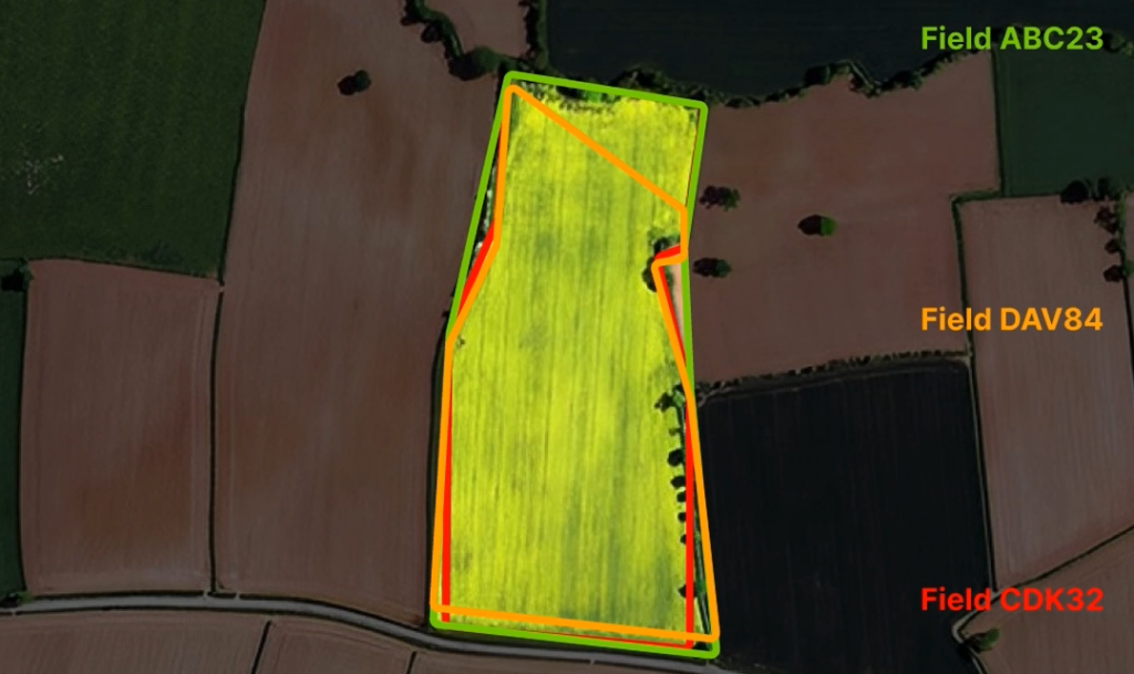
Imagine living in a town where every business, citizen, and public service provider names streets in a different way: it would be impossible to provide a unique address and do simple tasks such as receiving mail or arranging to meet. Rather than having a ‘unified picture’, everyone’s knowledge of the space would be limited to their usual areas of interest and never beyond. This is exactly what happens today in agriculture. Each company maps the land in their supply-chain to provide services to farmers, or to invest in carbon offsets, for example, creating a ‘multiverse’ of overlapping mapping systems that describe the same land in uncoordinated and often conflicting ways.
This makes it impossible for stakeholders in the industry to effectively communicate and share actionable information (or ‘intelligence’, as we say) in a way that is compatible with other stakeholders and with farmers. While each organisation may have a piece of information, without a scalable and standardised reference system, data discoverability becomes extremely complex. Making the most out of agricultural data needs to begin with an easy-to-use system for all.
Fragmentation and data silos have been a key challenge for years. While many startups focus specifically on micro-level compatibility between different services, a broad, systematic approach that can cover the entire world is required to democratise access to data and create the conditions to mobilise climate finance for the transformation of the sector.
Global FieldID
This system was created to tackle the challenges associated with data fragmentation and provide a unified geospatial reference system for farm and field-level data. The service first creates a registry of field polygons at the national level, and then keeps track of subsequent changes in their shapes over time. By assigning a unique alphanumeric code to each plot of land, the Global FieldID system creates a simple way to transform spatial information into standardised codes. These can then be used freely by stakeholders across the supply chain, including digital farming tool providers, farmers, purchasing managers and more.
Available as an API and with an easily accessible user interface, the service seamlessly integrates with existing platforms, automatically syncing updates to fields across all linked Global FieldID applications.
Users can locate a field and know its ID by querying via specific latitude and longitude coordinates, an area of interest on the map, or also via their ‘own’ polygons (the application will return a matching score and assign the most probable ID or send an error message). Most importantly, since the database cannot be 100% accurate in describing millions of polygons, it is possible to add or modify the database by drawing or uploading new field boundaries.
Global FieldID is a foundational service for a future regulatory scenario where location information is going to be extremely relevant to document and report nature and climate-related impacts of supply-chains and to mobilise the required evidence from farmers and data partners. It is engineered to consolidate information from multiple digital farming tools, sensors, and external partners, into a unified dataset.
The service can also serve as a streamlined way to onboard farmers onto digital farming applications, by allowing them to upload or import their fields on a free service, without the need to define them repeatedly. By connecting existing tools with the API, the platform facilitates easy integration with farm management systems, enabling farmers and agribusinesses to exchange IDs without any change to their current workflows.
The common geospatial reference can be used for data sharing, therefore documentation of farming practices becomes easier and less cumbersome.
The difference in mapping fields across the world
The intricacies of mapping agricultural fields vary across different parts of the world, reflecting the diversity in landscapes and farming techniques. In countries like the United States, the task is comparatively straightforward due to the presence of large, clearly marked fields. These extensive, regular plots are easily identifiable and can be mapped with distinct boundaries that are visible via satellite imagery. This clarity and consistency simplify the process of data gathering and field recognition.
In contrast, certain farming systems present a more complex picture. In smallholder markets with tiny land parcels or where tree crops are cultivated, for instance, the delineation of actual boundaries is much more complex. Mapping smaller plots with freely available remote sensing imagery can be challenging and may significantly increase the costs of providing and maintaining these services, potentially to unsustainable levels. Other factors like frequent cloud coverage may make the process complicated too.
This is where Global FieldID features become useful. The system’s strength lies in its user-centric approach, allowing for alternative (including private) sources of data to be ingested, and users (farmers, agronomists, retailers) to modify and more accurately define their own field boundaries. By allowing users to delineate their own fields, the system ensures that each plot is accurately represented, considering its unique characteristics.
This adaptability highlights the significance of Global FieldID as a universal solution. It facilitates effective field mapping across different regions, accommodating the broad spectrum of agricultural practices and conditions. The capacity for users to contribute precise, localised data enhances the system’s overall accuracy and relevance, building over time to what could become the most accurate source of agricultural-related location information.
The ‘split-and-merge’ functionality helps maintain accurate historical records of field geometries’ evolution. Every change is carefully recorded to maintain an ongoing history of the land plots.
In essence, Global FieldID is a hybrid between ‘Google Maps’ and ‘Wikipedia’. A universal tool creating de facto standardisation in geospatial reference systems to more efficiently and transparently enable data exchange in agriculture, leading the way for more climate finance, better services and cheaper access to capital for farmers that invest in regenerative farming practices, for example.
The bottom line
As a system based on network effect, Global FieldID’s effectiveness depends on widespread adoption. As more farmers and organisations adopt the system, the chances for effective collaboration across the entire supply-chain increases. We believe that this will be key to transitioning towards a nature-positive food system.
For this reason, Varda and its parent company (Yara International) have decided to offer the service under a multi-stakeholder, not-for-profit consortium, to ensure it will provide benefits to all industry actors, in particular to farmers that are facing increasing pressure to comply with regulations requesting evidence about farming practices.
The consortium will be aimed at forming an ‘Open Nature Intelligence Exchange’ (ONIX), which will serve as a federated network comprising data and solution providers. Its purpose is to accelerate systemic agricultural transformation through the secure sharing of data among stakeholders at all stages of the value chain. At the heart of ONIX’s mission lies a goal to support the frontlines of food production – farmers – by mobilising more funds to aid them. There will be a difficult, and sometimes risky, transition to new farming practices, but it will be crucial to offer a new source of revenue through the data that is generated, as well as recognising their role as stew