The UK Soil Observatory (UKSO) is an award-winning and free-to-use online service that enables everyone to view soil datasets from nine research organisations. Russell Lawley (Geo-Properties and Resources Team Lead) from the British Geological Survey explains how the resource has developed to provide significant benefits to the agricultural sector, what information you can expect to find, and how UK farming will play a major role in soil research in future.
The importance of soil to the UK and its role in supporting our environment and livelihoods will likely be among one of the most critical topics of the next decade. There is still some way to go, but soilhealth and resilience are at the heart of the new agricultural policy, and research investment from commercial and academic resources is now rising. As scientists, we are continuing to sound the alarm about the important connection between soil health, sustainable agriculture and tackling the climate crisis.
Each year, more attention turns to the important relationship between soil and climate. The availability of soil data and the significant increase in technology in agriculture, has been key to the transformation of people’s perceptions and understanding of what goes on beneath our feet. The ethos behind UKSO is that no one should have to start with a blank map when it comes to soils information. When UKSO started in 2014, it had a tiny number of users, accessing a handful of archived soil maps.
As well as data from the British Geological Survey, other partners contributing include the Natural Environment Research Council (NERC), Center for Ecology and Hydrology, the James Hutton Institute, Cranfield University, Rothamsted Research, AgriFood and Biosciences Institute, Forestry Commission and Forest Research. What began as a platform that caters for a wide audience, aiming to provide everyone with free access to soils data for the purpose of educating people about soils, has quickly evolved for use by key industries such as agriculture. Today, we are approaching 190 online maps – many with regional, if not national coverage – and the data is being accessed by a wide range of users every week. This includes farmers exploring their options to move into viticulture or forestry, to agronomists and contractors checking the ‘lie of the land’ before considering new territories.
We provide mapping for England, Wales, Scotland and Northern Ireland with access to over 180 layers of data covering physical, chemical and biological characteristics including type, texture and grain size.
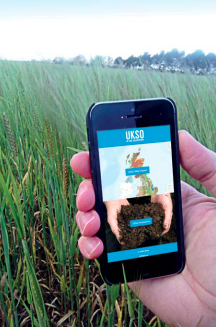
We are also providing more services for landscape domains and hydrology. Using UKSO, it’s possible to explore soil carbon, soil chemistry, pH, moisture, texture, type and agronomy, even upto-date surface slope data. The online maps can all be viewed on the UKSO platform ‘Map Viewer’ via mobiles phones, tablets, and desktop.
Many farm-mapping software applications can also use the web mapping services directly – for increased convenience, and better integration into farming systems. It also offers access to a number of resources through the UKSO website, including a series of quick-access static maps and exports from UKSO’s Map Viewer which are coupled with contact information and usage. It houses policies and guides for agriculture and industry and a selection of other useful apps and services which can help you find out more about soils in your area. These resources are only likely to grow in future as the service evolves.
What can you do with UKSO?
Over 180 layers of data can be viewed using the UKSO map viewer, which can be used to gather information about soil type, texture and grain size and a wide range of physical, chemical and biological properties. Users can also view the data within their own mapping software or apps. This includes Soilscapes, a 1:250,000 scale, simplified soils dataset for England and Wales which shows, in simple terms, what the likely soil conditions are at any point in the landscape by reference to one of 27 different broad types of soil. The users can benefit from extensive data about their soil chemistry as UKSO draws together data from the National Soil Inventory (NSI).
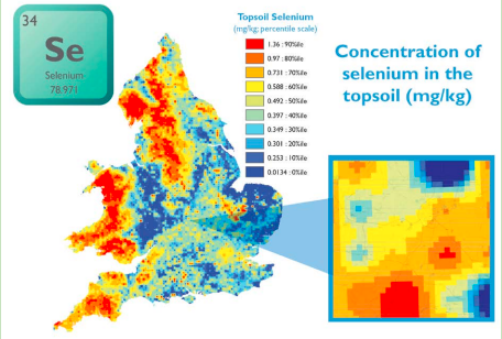
Other features include soil biodiversity data relevant to topsoil microbes and organic carbon concentrations, as well as topsoil nutrients, soil moisture and soil PH data from the Countrywide Survey (CS). This includes CS topsoil bulk density data, representative of 0-15cm, and maps covering Great Britain’s BioSoil pH data for a range of soil depths.
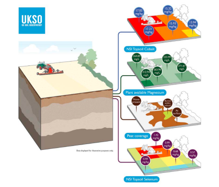
Planners and land managers can even benefit from surface data detailing for example, ruggedness, slope, and profile curvature derived from Ordnance Survey (OS) Terrain 50 elevation data, a dataset representing the physical shape of the real world. You can also access an archive of soilrelated resources, news and information such as soil apps, publications, events and research projects. Recent updates and future developments Right now, a key focus for UKSO is releasing more data for the agricultural sector. In January 2020, we launched new maps relevant to mixed-arable and pasture farmers directly relevant to ruminant health. The maps show regional levels and availability of the element magnesium in soil.
Low magnesium status (hypomagnesaemia) gives rise to tetany, or staggers, in ruminants. These conditions are remarkably widespread among ruminants in Europe, often with high fatality rates affecting business profitability. The data is designed to help understand the natural availability of these minerals in soils, and their likely uptake into plants. It can also inform the need to plan for supplementary feeds, sourcing grazing or forage from higher magnesium soils, or just for monitoring cattle if necessary. The research was funded by the Biotechnology and Biological Sciences Research Council (BBSRC) and the Natural Environmental Research Council (NERC). Both organisations have significant research areas devoted to food security issues. Using UKSO as a readily available toolkit for such data, will continue to ensure that industries like agriculture can benefit from high-quality research as quickly as possible.
How will UKSO adapt in future?
For agriculture, the upcoming Environmental Land Management scheme will see many changes in how we value our environment. With an increased awareness of soil health and resilience, there are likely to be inevitable changes to environmental regulations. A key part of future work for UKSO will be to provide an increasing array of data to support decision-making and compliance with changing environmental regulation. UKSO has already started to respond to such changes. We are currently trialling national maps of slope, so that agronomists who are preparing for changes to agricultural run-off regulations, can start to assess which parcels of land may be increasingly affected by the new rules.
We have responded to the renewed investment in peatland restoration by providing higher resolution peat mapping across Great Britain. The aim is to enable users to assess how much peat is present (or securely sequestered beneath it), assisting effective and responsible land management. Whilst traditional soil maps are still the most popular layers being viewed, demand has increased for datasets that answer specific questions relating to the land. We’re keen to ensure the service remains highly responsive to user feedback, who really are at the heart of what UKSO provides, and will fuel its future capabilities. Current feedback is pointing towards a greater demand for ever-higher map resolution and more frequent updates and that’s something we’re working hard to address.
Over the next 12-24 months, we anticipate that UKSO partners will be refining a number of other datasets. These include:
• improved texture descriptions for percentages of clay, sand and silt via laser-granulometry of 72,000 soil samples;
• Revised soil and sub-soil descriptions;
• New, very-high resolution, terrain datasets derived from Environment Agency Lidar survey;
• New trial models of soil erosion and soil compaction susceptibility;
• Improved options for using citizen science (the agricultural sector sharing their experience of their soils) and the potential for storing more data from soil sampling and field trials.
How you can help UKSO to grow
We are keen to continue learning about the needs of the agricultural sector and the specific needs of the direct-drilling community, who have already implemented changes to their land management to help improve soil resilience. We provide a contact form on the UKSO website (ukso.org/contact) where you can formulate your feedback and help to steer the development of the UKSO.
In particular, we would welcome thoughts from the industry such as:
• The soil or landscape datasets that you think should be in UKSO relevant to your sector, but might be currently missing.
• Soil or landscape datasets in UKSO that you find useful, but would like to see updated or improved, which ones and how.
• Suggestions for new datasets, or soil characteristics that would help you make better decisions about your soils, or insight into what your ‘go-to’ dataset would be for your work.
• Sources of new datasets such as drone, or smart-agriculture telemetry, that you think should be collated into UKSO.
Direct feedback will not only help to continue developing UKSO as usercentred platform, but insights like this can help to support future research. It’s important we work collaboratively to ensure that soil health is given the attention it deserves in the climate change debate.
UKSO is funded by the Natural Environment Research Council (NERC), and Biotechnology and Biological Sciences Research Council (BBSRC). For more information visit: http://www.ukso.org