New technologies for understanding the benefits of regenerative agriculture and cover crops
Sophia Burke, AmbioTEK CIC, Mark Mulligan, King’s College London and Shaun Dowman, Affinity Water

Affinity Water is a drinking water supply company in the south-east of England. Supplying water in an area designated as being under ‘serious water stress’, it is critical that the company manages its water resources sustainably now and into the future. When it rains, land management can have a big influence on the quality and quantity of water that reaches groundwater aquifers. Given that much of the land perched above the aquifers is agricultural, there is a great opportunity for water companies, like Affinity Water to work with farmers to better understand and enhance the benefits that good soil management can have for the water environment. Good soil health delivered through regenerative farming, no-till or conservation agriculture can offer many benefits such as increased water retention, improved infiltration, reduced run-off and less pollution.
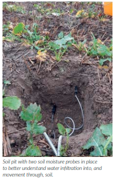
Measuring the impact of soil management practices on the water environment can be difficult, especially when attributing effects upon, and rewarding, the actions of individual farms across a large catchment, but through field trials, Affinity Water have been developing their knowledge and understanding in this area. Affinity Water are utilising new technologies developed at King’s College London and installed and maintained by AmbioTEK CIC. In a number of small-scale field trials they aim to understand how regenerative agriculture and different cover crops can help reduce runoff and nutrient loss as well as the influence they have on infiltration and potential aquifer recharge.
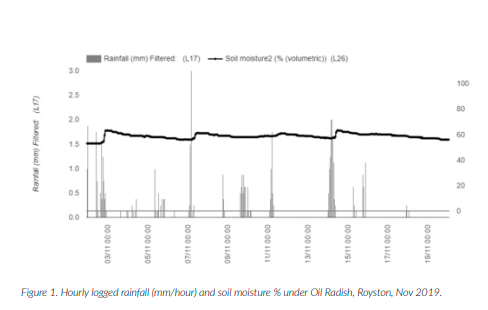
The measured soil moisture and rainfall for one of the sites is shown below (Figure 1). There is a clear soil moisture response to the measured rainfall, followed by a relatively rapid decline with drainage and crop water use. Measuring these parameters in real time on different cover crop mixes and comparing it to a plot left bare builds an understanding of the effect of cover crops on infiltration. Interestingly, the results from this year’s trials highlighted that very little water was ‘lost’ through evapotranspiration in the cover crop plots over the autumn/winter months. It is sometimes assumed that cover crops may ‘compete’ with the interests of a water company and will use water that may otherwise be directed down into the aquifer, but this study suggests that this is not the case.
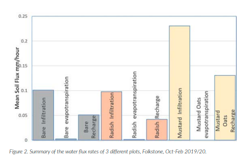
The results also highlight that a mustard/ oat cover crop may allow greater water infiltration when compared to a straight radish mix (Figure 2). Further work is needed to confirm this.
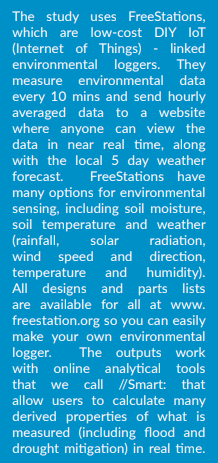
How can new IoT-linked monitoring technology be used by farmers in the future?
Landscapes of the future will be intensively monitored in real time by farmers, companies, environmental authorities and governments with the aim of improved management and early warning to the benefit of all. Internet-connected technology is already transforming our knowledge of soil, water, climate, food production and the production of public goods (ecosystem services), which are nature’s contributions to people provided by farmland. Regulators and legislators are looking to incentivise management for improved provision of public goods, such as clean water and carbon.
However, there are still challenges in understanding which public goods land provides to whom, how this varies spatially and over time and how management practices (such as tillage, choice of cover crops) impacts upon them. We can understand a lot by combining satellite data with computer models but these need to be combined with networked on-the-ground sensors such as FreeStations, collecting sitespecific detailed data.
Land provides both private goods for the market through the produce grown but also public goods in the ecosystem services provided. For example, changing land management will affect how much of the rainfall can infiltrate for use by the crop, and how much is ponded on the surface, which generates runoff, nutrient loss and soil erosion, and can also contribute to flooding downstream and to dry season flows. Since these services have real benefits to local, downstream and even global populations, public funds can be put to sustaining their provision whilst private funds underpin the markets for farm produce. If internet connected sensors, coupled with satellite remote sensing can quantify how land management on a farm mitigates flooding or drought downstream, or provides clean water, carbon or any other valuable ecosystem service this can contribute to more targeted payments for environmental land management
What do farmers want to monitor / measure on their land?
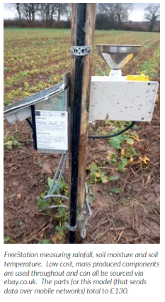
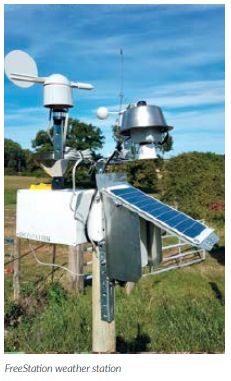
At present FreeStations measure soil moisture (with multiple probes at different depths), soil temperature, water quality and weather (rainfall, temperature, solar radiation, wind). Are there other variables you consider critical? If you are interested in installing or even building a DIY FreeStation, please check out www.freestation.org or contact us at sophia.burke@ambiotek.com.